CHARTS GALLERY
This inspiring gallery is included in the magnificent publication "TAKING POSSESSION, A SAGA OF THE GREAT SOUTH LAND" by Elynor Frances Olijnyk and illustrated by maritime artist, John Sheard Grafton.
Reproductions of original charts with kind permission from the Hydrographic Office of the United Kingdom are treasures to behold. The Secret Orders given to Captain James Cook to take possession of the great south land and the Norman Tindale Map of Aboriginal occupation at the time of his arrival add the the historic importance of the publication. The Photographic Art Gallery will reproduce the charts and illustrations of your choice to perfection on archival paper guaranteed to last for centuries. Dear lovers of Maritime History this is your once in a lifetime opportunity to add to the beloved decor of your home or office! The choice is yours! (Book $55.00 - Charts and illustrations from $185.00. Contact us for more information.

Book Cover
HM Armed Cutter INTEGRITY commanded by Charles Robbins RN bound for Van Diemen's Land 1802.

Raising the flag and taking possession of the Northern Van Diemen's Land for the Crown.
Two Colonial Vessels, HMS BUFFALO and HM Armed Cutter INTEGRITY anchored in Outer Cove. Paterson claiming the land for England, 11th Nov. 1804.

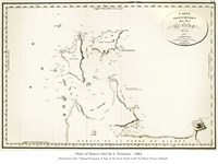
Chart of Port Phillip Bay, soundings by Robbins & coastline by Grimes.
Chart reveals the discovery of freshwater river, the Yarra - 3rd Feb. 1803. Chart used by Flinders in his historic maps of Terra Australis.

Act. Lieut. Charles Robbins RN in CUMBERLAND arrives Sea Elephant Bay, King Island, Dec. 8th 1802
Governor King directed Robbins in CUMBERLAND to assert possession of King Island, Bass Strait & Van Diemen's Land for the Crown under the watch of the French.

Commander Act. Lieut. Charles Robbins RN ploughs the sea in INTEGRITY.
Launched from King's Shipyard, Sydney town by Gov. King 13th Jan. 1804. Robbins would sail her on her maiden voyage.

Charles Robbins & company rescued from French
PHOENIX & crew rescue young Robbins, 1797.

The Channel Fleet guarded English shores from the French invaders 1796.
Both Robbins and Flinders were on board confronting the French and defending England.

French Citizens Freycinet & Boulanger chart the Hunter's Isles for Captain Nicolas Baudin 1802
One of two charts by the French on board CASUARINA. Both making an inaccurate observation of NW Van Diemen's Land.

The first accurate chart of the Hunter Island Group in Bass's Strait.
An amazing chart by young Robbins, Captain of HM Armed Cutter INTEGRITY. The chart revealing the corrected position of Cape Albany Otway by Robbins - December 1804.

Raising the flag under the watch of the French, King Island Dec. 1802
Act. Lieut. Charles Robbins puts ashore and raises the Union Jack in a large gum tree with the ceremony of taking possession for England.

The LADY NELSON under command of Lieut. James Grant arrives from England to aid exploration of new colony.
A small vessel of 60 tons with three sliding keels for shallow water exploration proved a valuable asset to the new colony.

INTEGRITY, now disarmed set sails for South America
Act .Leut. Charles Robbins and crew bid farewell to the shores of NSW never to return!

Robbins Island together with all islands of Bass's Strait is a haven for sea birds.
Birds delight in the clean air as they ride the winds over Robbins Island.

Commander Nicolas Baudin ordered the investigation of the islands south of King Island.
Acting on orders from Commander Baudin in LE GEOGRAPHE, Freycinet proceeded with haste to chart Robbins Island as an extension of the mainland.

Surveyor Charles Grimes & Captain Charles Robbins charted the coast and recorded inland landscape of King Island for Governor King.
After claiming King Island & Van Diemen's Land for the Crown under the watch of the French, Robbins proceeded with Grimes to chart the Island.

Governor John Hindmarsh disembarks from Buffalo - Holdfast Bay, SA 28th Dec. 1836
BUFFALO anchored Holdfast Bay SA Dec. 1836. Governor & Settlers ferried ashore.

Captained by Admiral Lord Howe of the Channel Fleet
This mighty ship sails to confront the French 1797.

Flinders prepares to circumnavigate Terra Australis
INVESTIGATOR is loaded with men and supplies, July 1802.

The boy Charles Robbins listens to stories of life at sea.
On the docks of Barnstaple, Devon, a young boy dreams of life at sea.